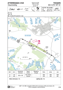


LFCT - Thouars
Located in Thouars, France
ICAO - LFCT, IATA -
Data provided by AirmateGeneral information
Coordinates: N46°57'43" W0°9'10"
Elevation is 341 feet MSL.
Magnetic variation is 0.38° East View others Airports in Poitou-Charentes
Operational data
Special qualification required
Current time UTC:
Current local time:
Weather at : LFBI - Poitiers Biard ( 54 km )
TAF: TAF LFBI 172300Z 1800/1824 VRB03KT 3000 BR NSC TEMPO 1800/1808 0300 FG VV/// BECMG 1808/1810 9999 NSW SCT025 TEMPO 1811/1821 4000 SHRA SCT030CB PROB30 TEMPO 1811/1816 2000 TSRA BKN025CB
Communications frequencies: [VIEW]
Runways:
| RWY identifier | QFU | Length (ft) | Width (ft) | Surface | LDA (ft) |
| 12 | 119° | 3458 | 328 | GRASS | 3458 |
| 30 | 299° | 3458 | 328 | GRASS | 2933 |
Airport contact information
Address: Thouars France
Fuel provider

Other aviation service providers
Aviation club (not for profit)

Club Rsa Ailes Anciennes Thouarsaises
Club Rsa Ailes Anciennes Thouarsaises
ailesanciennesthouarsaises@aol.com0611920158
