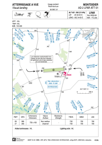


LFAR - Montdidier
Located in Montdidier, France
ICAO - LFAR, IATA -
Data provided by AirmateGeneral information
Coordinates: N49°40'23" E2°34'9"
Elevation is 358 feet MSL.
Magnetic variation is 1.05° East View others Airports in Picardie
Operational data
Special qualification required
Current time UTC:
Current local time:
Weather at : LFAQ - Albert Bray ( 34 km )
METAR: LFAQ 161200Z AUTO 28007KT 250V320 9999 SCT019/// BKN027/// BKN048/// ///TCU 16/12 Q1005 TEMPO 4000 SHRA BKN014 BKN020CB
TAF: TAF LFAQ 161100Z 1612/1621 25010KT 9999 BKN030 TEMPO 1612/1616 4000 SHRA BKN014 BKN020CB BECMG 1616/1618 VRB03KT
Communications frequencies: [VIEW]
Runways:
| RWY identifier | QFU | Length (ft) | Width (ft) | Surface | LDA (ft) |
| 09 | 86° | 2461 | 328 | GRASS | 2461 |
| 27 | 266° | 2461 | 328 | GRASS | 2461 |
Airport contact information
Address: Montdidier France

