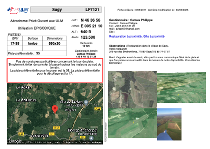


LF7121 - Sagy
Located in Sagy, France
ICAO - , IATA -
Data provided by AirmateGeneral information
Coordinates: N46°36'56" E5°21'10"
Elevation is 640 feet MSL.
View others Airports in Franche-Comté
Operational data
Special qualification required
Current time UTC:
Current local time:
Weather at : LFGJ - Dole Tavaux ( 48 km )
METAR: LFGJ 172300Z AUTO 13003KT CAVOK 10/09 Q1012
TAF: TAF LFGJ 171400Z 1715/1724 22004KT CAVOK PROB30 1715/1717 FEW040TCU
Communications frequencies: [VIEW]
Runways:
| RWY identifier | QFU | Length (ft) | Width (ft) | Surface | LDA (ft) |
| 17 | 0° | 1804 | 98 | GRASS | |
| 35 | 0° | 1804 | 98 | GRASS |
Airport contact information
Address: Sagy France