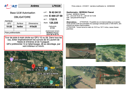


LF6538 - Anères
Located in Loures-Barousse, France
ICAO - , IATA -
Data provided by AirmateGeneral information
Coordinates: N43°4'51" E0°27'59"
Elevation is 1725 feet MSL.
View others Airports in Midi-Pyrénées
Operational data
Special qualification required
Current time UTC:
Current local time:
Weather at : LFBT - Tarbes Lourdes Pyrenees ( 40 km )
METAR: LFBT 162230Z AUTO 16003KT 110V180 9999 SCT100 10/09 Q1009 NOSIG
TAF: TAF LFBT 161700Z 1618/1718 VRB03KT 9999 SCT045 BKN060 TEMPO 1618/1619 FEW025CB PROB30 TEMPO 1618/1619 TS BECMG 1619/1621 CAVOK PROB30 TEMPO 1704/1713 -SHRA BKN050TCU PROB40 TEMPO 1713/1718 4000 SHRA FEW030CB BKN040TCU PROB30 TEMPO 1714/1717 VRB13KT TS SCT030CB
Communications frequencies: [VIEW]
Runways:
| RWY identifier | QFU | Length (ft) | Width (ft) | Surface | LDA (ft) |
| 10 | 0° | 1312 | 49 | GRASS | |
| 28 | 0° | 1312 | 49 | GRASS |
Airport contact information
Address: Loures-Barousse France