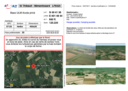


LF6025 - St Thibault - Ménantissard
Located in Saint-Thibault, France
ICAO - , IATA -
Data provided by AirmateGeneral information
Coordinates: N49°41'36" E1°48'44"
Elevation is 660 feet MSL.
View others Airports in Upper Normandy
Operational data
Special qualification required
Current time UTC:
Current local time:
Weather at : LFOB - Beauvais Tille ( 34 km )
METAR: LFOB 111800Z AUTO 08005KT CAVOK 23/12 Q1016 NOSIG
TAF: TAF LFOB 111700Z 1118/1218 10008KT CAVOK TEMPO 1212/1218 VRB20G35KT 1500 TSRAGR SCT014 BKN030CB
Communications frequencies: [VIEW]
Runways:
| RWY identifier | QFU | Length (ft) | Width (ft) | Surface | LDA (ft) |
| 07 | 0° | 1476 | 82 | GRASS | |
| 25 | 0° | 1476 | 82 | GRASS |
Airport contact information
Address: Saint-Thibault France