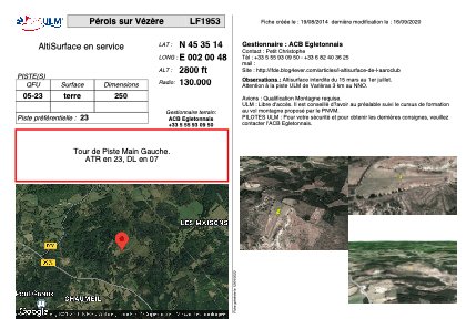


LF1953 - Pérols sur Vézère
Located in Pérols-sur-Vézère, France
ICAO - , IATA -
Data provided by AirmateGeneral information
Coordinates: N45°35'14" E2°0'48"
Elevation is 2800 feet MSL.
View others Airports in Limousin
Operational data
Special qualification required
Current time UTC:
Current local time:
Weather at : LFBL - Limoges Bellegarde ( 71 km )
METAR: LFBL 190200Z AUTO 03005KT CAVOK 10/09 Q1013 TEMPO 0500 FG VV///
TAF: TAF LFBL 182300Z 1900/1924 VRB03KT CAVOK PROB40 TEMPO 1902/1906 0500 FG VV/// TEMPO 1912/1921 4000 SHRA BKN030TCU PROB30 TEMPO 1915/1920 VRB15G25KT 2000 TSRA BKN010 BKN025CB
Communications frequencies: [VIEW]
Runways:
| RWY identifier | QFU | Length (ft) | Width (ft) | Surface | LDA (ft) |
| 05 | 0° | 820 | 0 | DIRT | |
| 23 | 0° | 820 | 0 | DIRT |
Airport contact information
Address: Pérols-sur-Vézère France