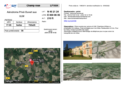


LF1654 - Champ rose
Located in Saint-Laurent-de-Belzagot, France
ICAO - , IATA -
Data provided by AirmateGeneral information
Coordinates: N45°21'24" E0°6'35"
Elevation is 210 feet MSL.
View others Airports in Aquitaine
Operational data
Special qualification required
Current time UTC:
Current local time:
Weather at : LFBU - Angouleme Brie Champniers ( 42 km )
METAR: LFBU 181300Z AUTO VRB02KT 9999 SCT038/// BKN046/// BKN086/// ///CB 20/10 Q1012 TEMPO 1500 -TSRA
TAF: TAF LFBU 181100Z 1812/1912 27005KT 9999 SCT025 TEMPO 1812/1818 4000 -SHRA BKN030TCU PROB30 1813/1817 1500 -TSRA BKN020CB BECMG 1821/1824 VRB03KT 3000 BR BKN003 BECMG 1900/1903 0800 FG VV/// TEMPO 1903/1906 0200 BECMG 1906/1908 9999 NSW BKN010 BECMG 1910/1912 CAVOK
Communications frequencies: [VIEW]
Runways:
| RWY identifier | QFU | Length (ft) | Width (ft) | Surface | LDA (ft) |
| 17 | 0° | 2362 | 82 | GRASS | |
| 35 | 0° | 2362 | 82 | GRASS |
Airport contact information
Address: Saint-Laurent-de-Belzagot France