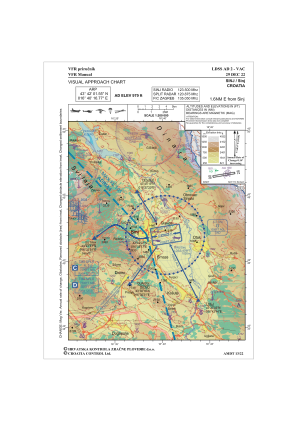
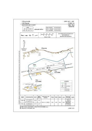


LDSS - Sinj
Located in Sinj, Croatia
ICAO - LDSS, IATA -
Data provided by AirmateGeneral information
Coordinates: N43°42'2" E16°40'17"
Elevation is 979 feet MSL.
Magnetic variation is 5° East View others Airports in Split-Dalmatia
Operational data
Special qualification required
Current time UTC:
Current local time:
Weather at : LDSP - Split / Kastela ( 35 km )
METAR: LDSP 271130Z 23010KT CAVOK 24/14 Q1018 NOSIG
TAF: TAF LDSP 271125Z 2712/2812 23008KT 9999 FEW050 TX25/2712Z TN16/2803Z PROB40 TEMPO 2712/2715 23010KT BECMG 2717/2719 03004KT BECMG 2808/2810 23012KT PROB30 TEMPO 2810/2812 TS FEW040CB
Communications frequencies: [VIEW]
Runways:
| RWY identifier | QFU | Length (ft) | Width (ft) | Surface | LDA (ft) |
| 08 | 81° | 3362 | 189 | GRAS | 3366 |
| 26 | 261° | 3362 | 189 | GRAS | 3366 |
Airport contact information
Address: Sinj Croatia
Web: www.aeroklubsinj.hr
