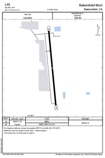


L45 - Bakersfield Muni
Located in Bakersfield, United States
ICAO - L45, IATA -
Data provided by AirmateGeneral information
Coordinates: N35°19'30" W118°59'46"
Elevation is 378 feet MSL.
Magnetic variation is 14° East View others Airports in California
Operational data
Special qualification required
Current time UTC:
Current local time:
Weather at : KBFL - Meadows Fld ( 13 km )
METAR: KBFL 192054Z 31006G14KT 10SM OVC050 26/13 A2989 RMK AO2 SLP116 T02610128 56013
TAF: KBFL 191720Z 1918/2018 VRB03KT P6SM FEW060 BKN200 FM192100 32008KT P6SM SCT060 BKN200 FM200200 VRB03KT P6SM SCT200
Communications frequencies: [VIEW]
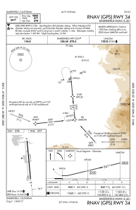
Runways:
| RWY identifier | QFU | Length (ft) | Width (ft) | Surface | LDA (ft) |
| 16 | 175° | 4000 | 75 | ASPH | |
| 34 | 355° | 4000 | 75 | ASPH |
Airport contact information
Address: Bakersfield United States
