


L41 - Marble Canyon
Located in Marble Canyon, United States
ICAO - L41, IATA -
Data provided by AirmateGeneral information
Coordinates: N36°48'39" W111°38'40"
Elevation is 3603 feet MSL.
Magnetic variation is 13° East View others Airports in Arizona
Operational data
Special qualification required
Current time UTC:
Current local time:
Weather at : KPGA - Page Muni ( 22 km )
METAR: KPGA 210953Z AUTO 26004KT 10SM FEW120 16/02 A2990 RMK AO2 SLP066 T01560022
TAF: KPGA 210520Z 2106/2206 22007G16KT P6SM SKC FM210800 VRB04KT P6SM SKC FM212100 32008KT P6SM SKC FM220200 VRB04KT P6SM SKC
Communications frequencies: [VIEW]
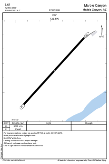
Runways:
| RWY identifier | QFU | Length (ft) | Width (ft) | Surface | LDA (ft) |
| 03 | 42° | 3715 | 35 | ASPH | |
| 21 | 222° | 3715 | 35 | ASPH |
Airport contact information
Address: Marble Canyon United States