


KYNG - Youngstown/Warren Rgnl
Located in Youngstown/Warren, United States
ICAO - YNG, IATA - YNG
Data provided by AirmateGeneral information
Coordinates: N41°15'42" W80°40'49"
Elevation is 1191 feet MSL.
Magnetic variation is -08° East View others Airports in Ohio
Operational data
Special qualification required
Current time UTC:
Current local time:
Weather
METAR: KYNG 160251Z 02008KT 10SM FEW065 BKN090 17/14 A2980 RMK AO2 SLP086 T01670139 51009
TAF: KYNG 152330Z 1600/1624 03006KT 6SM -SHRA SCT030 SCT100 BKN250 FM160600 01004KT 6SM BR BKN026 FM160800 VRB03KT 3SM BR BKN015 FM161000 VRB03KT 2SM BR BKN003 FM161300 VRB03KT P6SM BKN008 FM161500 36004KT P6SM SCT050
Communications frequencies: [VIEW]
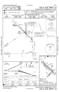
Runways:
| RWY identifier | QFU | Length (ft) | Width (ft) | Surface | LDA (ft) |
| 05 | 45° | 5002 | 150 | ASPH | 5002 |
| 23 | 225° | 5002 | 150 | ASPH | 5002 |
| 14 | 135° | 9003 | 150 | ASPH | 9003 |
| 32 | 315° | 9003 | 150 | ASPH | 9003 |
| 143 | 135° | 3501 | 60 | ASPH | 3500 |
| 323 | 315° | 3501 | 60 | ASPH | 3500 |
Airport contact information
Address: Youngstown/Warren United States