


KXNI - Andrew Othole Meml
Located in Zuni, United States
ICAO - XNI, IATA -
Data provided by AirmateGeneral information
Coordinates: N35°3'38" W108°56'15"
Elevation is 6371 feet MSL.
Magnetic variation is 09° East View others Airports in New Mexico
Operational data
Special qualification required
Current time UTC:
Current local time:
Weather at : KGUP - Gallup Muni ( 52 km )
METAR: KGUP 051453Z AUTO 21015G28KT 10SM CLR 14/M04 A2995 RMK AO2 PK WND 21028/1444 SLP032 T01391044 53002
TAF: KGUP 051140Z 0512/0612 20010KT P6SM BKN200 FM051500 21015G25KT P6SM BKN200 FM051800 21030G43KT 6SM BLDU SCT090 BKN200 FM060300 23025G37KT P6SM BKN090 FM060900 24013KT P6SM FEW100
Communications frequencies: [VIEW]
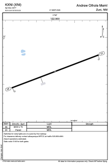
Runways:
| RWY identifier | QFU | Length (ft) | Width (ft) | Surface | LDA (ft) |
| 06 | 69° | 6000 | 75 | ASPH | |
| 24 | 249° | 6000 | 75 | ASPH |
Airport contact information
Address: Zuni United States