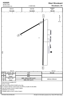


KWWR - West Woodward
Located in Woodward, United States
ICAO - WWR, IATA - WWR
Data provided by AirmateGeneral information
Coordinates: N36°26'17" W99°31'22"
Elevation is 2189 feet MSL.
Magnetic variation is 08° East View others Airports in Oklahoma
Operational data
Special qualification required
Current time UTC:
Current local time:
Weather
METAR: KWWR 291950Z AUTO 11006KT 10SM CLR 27/13 A3011 RMK AO2
TAF: KWWR 291731Z 2918/3018 14012KT P6SM SCT100 PROB30 3008/3010 4SM TSRA BR OVC010CB FM301000 17012G19KT P6SM BKN020 PROB30 3010/3016 4SM TSRA BR OVC009CB
Communications frequencies: [VIEW]
Runways:
| RWY identifier | QFU | Length (ft) | Width (ft) | Surface | LDA (ft) |
| 05 | 60° | 2500 | 60 | ASPH | |
| 23 | 240° | 2500 | 60 | ASPH | |
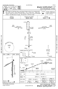
| 17 | 180° | 5502 | 100 | CONC | |
| 35 | 0° | 5502 | 100 | CONC |
Airport contact information
Address: Woodward United States