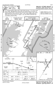
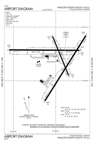


KWAL - Wallops Flight Facility
Located in Wallops Island, United States
ICAO - WAL, IATA - WAL
Data provided by AirmateGeneral information
Coordinates: N37°56'25" W75°27'59"
Elevation is 40 feet MSL.
Magnetic variation is -11° East View others Airports in Virginia
Operational data
Special qualification required
Current time UTC:
Current local time:
Communications frequencies: [VIEW]
Runways:
| RWY identifier | QFU | Length (ft) | Width (ft) | Surface | LDA (ft) |
| 04 | 32° | 8748 | 150 | OTHER | |
| 22 | 212° | 8748 | 150 | OTHER | |
| 10 | 90° | 8005 | 200 | OTHER | |
| 28 | 270° | 8005 | 200 | OTHER | |
| 17 | 158° | 4808 | 150 | ASPH | |
| 35 | 338° | 4808 | 150 | ASPH |
Airport contact information
Address: Wallops Island United States