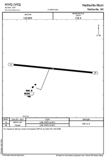


KVIQ - Neillsville Muni
Located in Neillsville, United States
ICAO - VIQ, IATA -
Data provided by AirmateGeneral information
Coordinates: N44°33'29" W90°30'44"
Elevation is 1237 feet MSL.
Magnetic variation is -01° East View others Airports in Wisconsin
Operational data
Special qualification required
Current time UTC:
Current local time:
Weather at : KMFI - Marshfield Muni ( 27 km )
METAR: KMFI 211854Z AUTO 14021G36KT 6SM RA BR OVC100 16/15 A2962 RMK AO2 PK WND 13038/1829 WSHFT 1749 LTG DSNT ALQDS PRESRR SLP030 P0007 T01560150
Communications frequencies: [VIEW]
Runways:
| RWY identifier | QFU | Length (ft) | Width (ft) | Surface | LDA (ft) |
| 10 | 96° | 3400 | 60 | ASPH | |
| 28 | 276° | 3400 | 60 | ASPH |
Airport contact information
Address: Neillsville United States