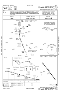
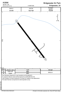


KVBW - Bridgewater Air Park
Located in Bridgewater, United States
ICAO - VBW, IATA -
Data provided by AirmateGeneral information
Coordinates: N38°22'0" W78°57'37"
Elevation is 1165 feet MSL.
Magnetic variation is -09° East View others Airports in Virginia
Operational data
Special qualification required
Current time UTC:
Current local time:
Weather
METAR: KVBW 271155Z AUTO 17008KT 10SM OVC023 10/08 A3040 RMK AO1 60003 70003 T00970075 10116 20090
Communications frequencies: [VIEW]
Runways:
| RWY identifier | QFU | Length (ft) | Width (ft) | Surface | LDA (ft) |
| 15 | 143° | 2745 | 60 | ASPH | |
| 33 | 323° | 2745 | 60 | ASPH |
Airport contact information
Address: Bridgewater United States