


KUBS - Columbus-Lowndes County
Located in Columbus, United States
ICAO - UBS, IATA - UBS
Data provided by AirmateGeneral information
Coordinates: N33°27'55" W88°22'51"
Elevation is 188 feet MSL.
Magnetic variation is -03° East View others Airports in Mississippi
Operational data
Special qualification required
Current time UTC:
Current local time:
Weather at : KGTR - Golden Triangle Rgnl ( 20 km )
METAR: KGTR 190756Z AUTO 00000KT 10SM CLR 18/18 A2993 RMK AO2 SLP142 T01830183
TAF: KGTR 190530Z 1906/2006 32005KT P6SM FEW035 FM191100 32002KT 5SM BR FEW035 FM191300 34003KT P6SM FEW035
Communications frequencies: [VIEW]
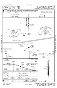
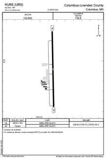
Runways:
| RWY identifier | QFU | Length (ft) | Width (ft) | Surface | LDA (ft) |
| 18 | 179° | 4503 | 100 | ASPH | |
| 36 | 359° | 4503 | 100 | ASPH |
Airport contact information
Address: Columbus United States