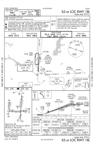
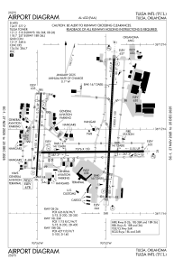


KTUL - Tulsa Intl
Located in Tulsa, United States
ICAO - TUL, IATA - TUL
Data provided by AirmateGeneral information
Coordinates: N36°11'54" W95°53'17"
Elevation is 677 feet MSL.
Magnetic variation is 03° East View others Airports in Oklahoma
Operational data
Special qualification required
Current time UTC:
Current local time:
Weather
METAR: KTUL 280553Z 16008KT 1SM R18L/P6000FT +TSRA BR SCT045CB OVC070 17/17 A2976 RMK AO2 WSHFT 0440 SLP069 CONS LTGICCCCG ALQDS TS ALQDS MOV NE P0106 60153 T01720167 10256 20167 402780167 53016
TAF: KTUL 280520Z 2806/2906 15015G25KT 6SM -TSRA OVC050CB TEMPO 2806/2808 VRB20G45KT 1SM +TSRA BKN025CB FM280800 17012G22KT 6SM -TSRA OVC050CB TEMPO 2808/2812 2SM +TSRA BR BKN015CB FM281200 17010KT 5SM -SHRA BR OVC015 FM281800 19008KT P6SM VCSH BKN050 PROB30 2818/2824 4SM -TSRA BKN025CB
Communications frequencies: [VIEW]
Runways:
| RWY identifier | QFU | Length (ft) | Width (ft) | Surface | LDA (ft) |
| 08 | 89° | 7376 | 150 | CONC | 7376 |
| 26 | 269° | 7376 | 150 | CONC | 7376 |
| 18R | 183° | 6101 | 100 | ASPH | 5101 |
| 36L | 3° | 6101 | 100 | ASPH | 5101 |
| 18L | 183° | 10000 | 150 | CONC | 10000 |
| 36R | 3° | 10000 | 150 | CONC | 10000 |
Airport contact information
Address: Tulsa United States