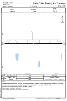


KTNT - Dade-Collier Training And Transition
Located in Miami, United States
ICAO - TNT, IATA -
Data provided by AirmateGeneral information
Coordinates: N25°51'43" W80°53'49"
Elevation is 12 feet MSL.
Magnetic variation is -05° East View others Airports in Florida
Operational data
Special qualification required
Current time UTC:
Current local time:
Weather at : KTMB - Miami Exec ( 52 km )
METAR: KTMB 120553Z AUTO 31008KT 10SM CLR 26/24 A2990 RMK AO2 SLP124 T02560239 10283 20239 58000 $
TAF: KTMB 120520Z 1206/1306 29007KT P6SM SKC FM120900 32007KT P6SM FEW040 FM121400 02008KT P6SM SCT050 SCT250 FM121800 10010G18KT P6SM SCT040 SCT060 FM130100 12008KT P6SM FEW040 SCT060
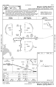
Communications frequencies: [VIEW]
Runways:
| RWY identifier | QFU | Length (ft) | Width (ft) | Surface | LDA (ft) |
| 09 | 90° | 10499 | 150 | ASPH | |
| 27 | 270° | 10499 | 150 | ASPH |
Airport contact information
Address: Miami United States