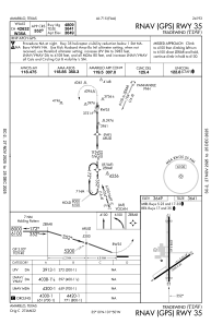


KTDW - Tradewind
Located in Amarillo, United States
ICAO - TDW, IATA - TDW
Data provided by AirmateGeneral information
Coordinates: N35°10'12" W101°49'33"
Elevation is 3648 feet MSL.
Magnetic variation is 08° East View others Airports in Texas
Operational data
Special qualification required
Current time UTC:
Current local time:
Weather at : KAMA - Rick Husband Amarillo Intl ( 12 km )
METAR: KAMA 211053Z 29013G24KT 10SM CLR 20/M01 A2973 RMK AO2 SLP004 T02001011
TAF: KAMA 211120Z 2112/2212 27015G23KT P6SM FEW240 FM220000 24015G23KT P6SM SKC FM220400 20008KT P6SM SKC FM220900 02012KT P6SM FEW250
Communications frequencies: [VIEW]
Runways:
| RWY identifier | QFU | Length (ft) | Width (ft) | Surface | LDA (ft) |
| 05 | 56° | 3000 | 60 | ASPH | |
| 23 | 236° | 3000 | 60 | ASPH | |
| 17 | 180° | 5098 | 60 | ASPH | |
| 35 | 360° | 5098 | 60 | ASPH | |
| H1 | 0° | 0 | 0 | UNK |
Airport contact information
Address: Amarillo United States
