


KTBN - Waynesville-St Robert Rgnl Forney Fld
Located in Fort Leonard Wood, United States
ICAO - TBN, IATA - TBN
Data provided by AirmateGeneral information
Coordinates: N37°44'30" W92°8'27"
Elevation is 1159 feet MSL.
Magnetic variation is 00° East View others Airports in Missouri
Operational data
Special qualification required
Current time UTC:
Current local time:
Weather
METAR: KTBN 281755Z AUTO 16014KT 10SM FEW100 SCT130 BKN150 20/16 A2985 RMK AO2 SLP103 60010 T01950155 10210 20161 58014 $
Communications frequencies: [VIEW]
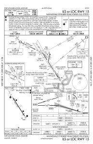
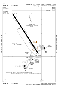
Runways:
| RWY identifier | QFU | Length (ft) | Width (ft) | Surface | LDA (ft) |
| 15 | 147° | 6037 | 150 | ASPH | |
| 33 | 327° | 6037 | 150 | ASPH |
Airport contact information
Address: Fort Leonard Wood United States