


KSYV - Sylvester
Located in Sylvester, United States
ICAO - SYV, IATA -
Data provided by AirmateGeneral information
Coordinates: N31°33'26" W83°53'39"
Elevation is 403 feet MSL.
Magnetic variation is -02° East View others Airports in Georgia
Operational data
Special qualification required
Current time UTC:
Current local time:
Weather at : KABY - Southwest Georgia Rgnl ( 29 km )
METAR: KABY 180913Z AUTO 00000KT 10SM OVC005 22/21 A2991 RMK AO2 T02220211
TAF: KABY 180803Z 1808/1906 17006KT P6SM OVC006 FM181200 20008KT P6SM VCTS SCT009CB BKN035 TEMPO 1813/1817 26020G35KT 2SM +TSRA BR FM181700 25011G20KT 5SM -TSRA FEW015 BKN040CB FM182100 24008KT P6SM VCSH BKN050 OVC100
Communications frequencies: [VIEW]
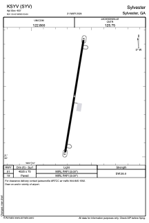
Runways:
| RWY identifier | QFU | Length (ft) | Width (ft) | Surface | LDA (ft) |
| 01 | 10° | 4525 | 75 | ASPH | |
| 19 | 190° | 4525 | 75 | ASPH |
Airport contact information
Address: Sylvester United States