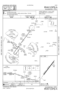
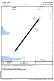


KSXL - Summersville
Located in Summersville, United States
ICAO - SXL, IATA -
Data provided by AirmateGeneral information
Coordinates: N38°13'54" W80°52'15"
Elevation is 1819 feet MSL.
Magnetic variation is -07° East View others Airports in West Virginia
Operational data
Special qualification required
Current time UTC:
Current local time:
Weather at : KBKW - Raleigh County Meml ( 54 km )
METAR: KBKW 272151Z AUTO 25006KT 10SM FEW120 24/08 A3027 RMK AO2 SLP225 T02390083 VISNO RWY19 $
TAF: KBKW 272125Z 2721/2818 23006KT P6SM BKN090 FM280200 23005KT P6SM SKC
Communications frequencies: [VIEW]
Runways:
| RWY identifier | QFU | Length (ft) | Width (ft) | Surface | LDA (ft) |
| 04 | 37° | 3015 | 50 | ASPH | |
| 22 | 217° | 3015 | 50 | ASPH |
Airport contact information
Address: Summersville United States