


KSTL - St Louis Lambert Intl
Located in St Louis, United States
ICAO - STL, IATA - STL
Data provided by AirmateGeneral information
Coordinates: N38°44'55" W90°22'12"
Elevation is 617 feet MSL.
Magnetic variation is -01° East View others Airports in Missouri
Operational data
Special qualification required
Current time UTC:
Current local time:
Weather
METAR: KSTL 030109Z 32013KT 3SM RA FEW017 BKN049 OVC080 19/16 A2984 RMK AO2 LTG DSNT W VIS NW 2 P0006 T01940161
TAF: KSTL 022329Z 0300/0406 19012G18KT 6SM SHRA BR VCTS SCT060 OVC090CB TEMPO 0300/0302 27030KT 2SM TSRA BR OVC020CB FM030300 VRB05KT 6SM -SHRA BR SCT040 FM030800 VRB05KT P6SM VCSH BKN015 FM031100 03006KT P6SM BKN008 FM031500 06006KT P6SM BKN026 FM031800 08007KT P6SM SCT060
Communications frequencies: [VIEW]
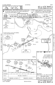
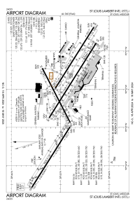
Runways:
| RWY identifier | QFU | Length (ft) | Width (ft) | Surface | LDA (ft) |
| 06 | 63° | 7603 | 150 | CONC | 7323 |
| 24 | 243° | 7603 | 150 | CONC | 7603 |
| 11 | 122° | 9000 | 150 | CONC | 9000 |
| 29 | 302° | 9000 | 150 | CONC | 9000 |
| 12L | 122° | 9013 | 150 | CONC | 8956 |
| 30R | 302° | 9013 | 150 | CONC | 9013 |
| 12R | 122° | 11020 | 150 | CONC | 10553 |
| 30L | 302° | 11020 | 150 | CONC | 10679 |
Airport contact information
Address: St Louis United States
