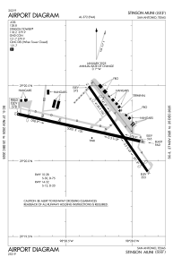


KSSF - Stinson Muni
Situé à San Antonio, United States
ICAO - SSF, IATA -
Données fournies par AirmateInformation générale
Coordonnées: N29°20'13" W98°28'16"
Élévation : 577 feet MSL.
Variation magnétique : 08° East Voir autres Aéroports à Texas
Données opérationnelles
Special qualification required
Heure actuelle UTC:
Heure actuelle locale:
Météo
METAR: KSSF 062153Z 15012KT 10SM BKN027 29/22 A2968 RMK AO2 SLP038 T02940222
TAF: KSSF 061726Z 0618/0718 15011KT P6SM BKN015 BKN028 OVC050 FM062000 15010KT P6SM OVC020 FM062100 14009KT P6SM BKN035 FM070600 17004KT 4SM BR OVC005 FM071600 10005KT 4SM HZ OVC015
Fréquences de communication: [VIEW]
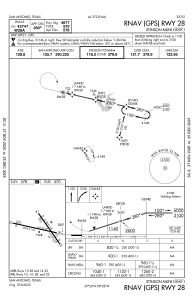
Pistes:
| Identifiant RWY | QFU | Longueur (ft) | Largeur (ft) | Surface | LDA (ft) |
| 09 | 103° | 5000 | 100 | ASPH | |
| 27 | 283° | 5000 | 100 | ASPH | |
| 14 | 145° | 4128 | 100 | ASPH | |
| 32 | 325° | 4128 | 100 | ASPH |
Coordonnées de l'aéroport
Adresse: San Antonio United States
