


KSNA - John Wayne/Orange County
Located in Santa Ana, United States
ICAO - SNA, IATA - SNA
Data provided by AirmateGeneral information
Coordinates: N33°40'32" W117°52'6"
Elevation is 55 feet MSL.
Magnetic variation is 12° East View others Airports in California
Operational data
Special qualification required
Current time UTC:
Current local time:
Weather
METAR: KSNA 260642Z AUTO 23003KT 10SM SCT017 SCT055 15/11 A3003 RMK AO2 T01500106
TAF: KSNA 260520Z 2606/2706 23005KT P6SM BKN040 FM260900 13005KT P6SM VCSH SCT015 OVC025 FM261900 21010G18KT P6SM BKN040 FM262300 24011G20KT P6SM BKN050 FM270200 26006KT P6SM BKN040
Communications frequencies: [VIEW]
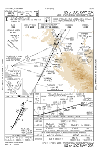
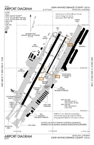
Runways:
| RWY identifier | QFU | Length (ft) | Width (ft) | Surface | LDA (ft) |
| 02L | 28° | 5700 | 150 | ASPH | 5700 |
| 02R | 28° | 2886 | 75 | ASPH | 2887 |
| 20L | 208° | 2886 | 75 | ASPH | 2887 |
| 20R | 208° | 5700 | 150 | ASPH | 5700 |
Airport contact information
Address: Santa Ana United States
Other aviation service providers
Repair station

Flight schools

Accelerated Flight & Instrument Training, Llc
Accelerated Flight & Instrument Training, Llc
training@afit-info.com+1(866)270-8224