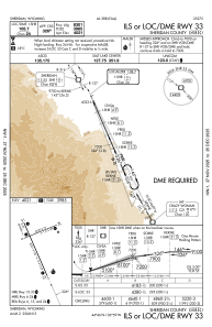


KSHR - Sheridan County
Located in Sheridan, United States
ICAO - SHR, IATA - SHR
Data provided by AirmateGeneral information
Coordinates: N44°46'9" W106°58'49"
Elevation is 4021 feet MSL.
Magnetic variation is 10° East View others Airports in Wyoming
Operational data
Special qualification required
Current time UTC:
Current local time:
Weather
METAR: KSHR 182253Z AUTO 07005KT 10SM CLR 18/02 A2986 RMK AO2 SLP108 T01830022
TAF: KSHR 181741Z 1818/1918 VRB06KT P6SM FEW250 FM182100 09008KT P6SM SCT250 FM190200 VRB06KT P6SM FEW150 BKN250
Communications frequencies: [VIEW]
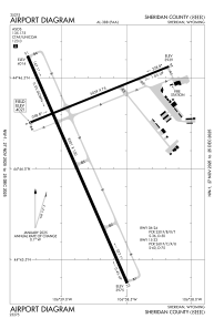
Runways:
| RWY identifier | QFU | Length (ft) | Width (ft) | Surface | LDA (ft) |
| 06 | 68° | 5039 | 75 | ASPH | 5039 |
| 24 | 248° | 5039 | 75 | ASPH | 5039 |
| 15 | 156° | 8301 | 100 | ASPH | 8301 |
| 33 | 336° | 8301 | 100 | ASPH | 8301 |
Airport contact information
Address: Sheridan United States
