


KSFF - Felts Fld
Located in Spokane, United States
ICAO - SFF, IATA -
Data provided by AirmateGeneral information
Coordinates: N47°40'59" W117°19'21"
Elevation is 1956 feet MSL.
Magnetic variation is 16° East View others Airports in Washington
Operational data
Special qualification required
Current time UTC:
Current local time:
Weather
METAR: KSFF 301753Z 23012KT 10SM SCT035 BKN045 07/M01 A3005 RMK AO2 SLP183 60000 T00721006 10078 20011 57001
TAF: KSFF 301721Z 3018/0118 22007KT P6SM FEW025 BKN060 FM302000 VRB03KT P6SM BKN080 FM011200 25003KT P6SM OVC100 FM011400 22006KT P6SM BKN050
Communications frequencies: [VIEW]
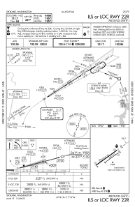
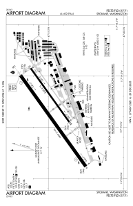
Runways:
| RWY identifier | QFU | Length (ft) | Width (ft) | Surface | LDA (ft) |
| 03W | 0° | 6000 | 100 | WATER | |
| 21W | 0° | 6000 | 100 | WATER | |
| 04L | 54° | 4499 | 140 | CONC | 4499 |
| 22R | 234° | 4499 | 140 | CONC | 4499 |
| 04R | 54° | 2650 | 75 | ASPH | 2650 |
| 22L | 234° | 2650 | 75 | ASPH | 2650 |
Airport contact information
Address: Spokane United States
