


KSDA - Shenandoah Muni
Located in Shenandoah, United States
ICAO - SDA, IATA -
Data provided by AirmateGeneral information
Coordinates: N40°45'6" W95°24'49"
Elevation is 971 feet MSL.
Magnetic variation is 05° East View others Airports in Iowa
Operational data
Special qualification required
Current time UTC:
Current local time:
Weather
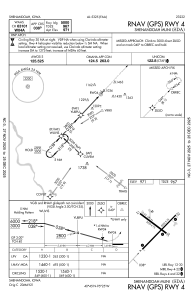
METAR: KSDA 201415Z AUTO 33012KT 10SM CLR 05/M04 A3043 RMK AO2
Communications frequencies: [VIEW]
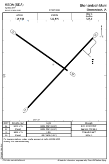
Runways:
| RWY identifier | QFU | Length (ft) | Width (ft) | Surface | LDA (ft) |
| 04 | 43° | 5000 | 75 | CONC | |
| 22 | 223° | 5000 | 75 | CONC | |
| 12 | 125° | 3439 | 75 | CONC | |
| 30 | 305° | 3439 | 75 | CONC |
Airport contact information
Address: Shenandoah United States