


KSBP - San Luis County Rgnl
Located in San Luis Obispo, United States
ICAO - SBP, IATA - SBP
Data provided by AirmateGeneral information
Coordinates: N35°14'14" W120°38'33"
Elevation is 212 feet MSL.
Magnetic variation is 15° East View others Airports in California
Operational data
Special qualification required
Current time UTC:
Current local time:
Weather
METAR: KSBP 190356Z 15003KT 7SM OVC007 15/12 A2997 RMK AO2 SLP148 T01500117
TAF: KSBP 190257Z 1903/1924 VRB03KT P6SM BKN007 FM190900 VRB03KT 1/2SM FG OVC003 FM191800 VRB03KT 6SM BR OVC015 FM192000 30010KT P6SM SCT015
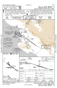
Communications frequencies: [VIEW]
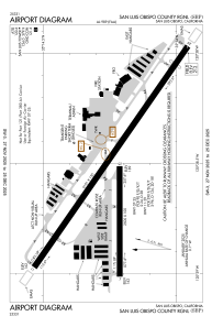
Runways:
| RWY identifier | QFU | Length (ft) | Width (ft) | Surface | LDA (ft) |
| 07 | 90° | 2500 | 100 | ASPH | 2500 |
| 25 | 270° | 2500 | 100 | ASPH | 2500 |
| 11 | 125° | 6101 | 150 | ASPH | 5300 |
| 29 | 305° | 6101 | 150 | ASPH | 5600 |
Airport contact information
Address: San Luis Obispo United States

