


KSAW - Marquette/Sawyer Rgnl
Located in Marquette, United States
ICAO - SAW, IATA - MQT
Data provided by AirmateGeneral information
Coordinates: N46°20'57" W87°23'47"
Elevation is 1204 feet MSL.
Magnetic variation is -04° East View others Airports in Michigan
Operational data
Special qualification required
Current time UTC:
Current local time:
Weather
METAR: KSAW 082245Z 06008KT 10SM OVC110 11/06 A2983
TAF: KSAW 081737Z 0818/0918 02008KT P6SM BKN022 FM081900 03010KT P6SM SCT030 BKN200 FM082300 01008KT P6SM SCT200 FM091300 02010KT P6SM BKN025 FM091700 02012KT P6SM BKN035
Communications frequencies: [VIEW]
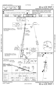
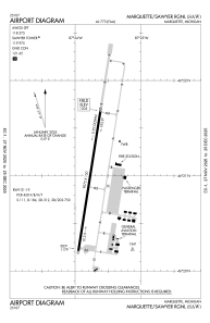
Runways:
| RWY identifier | QFU | Length (ft) | Width (ft) | Surface | LDA (ft) |
| 01 | 9° | 9072 | 150 | ASPH | 9072 |
| 19 | 189° | 9072 | 150 | ASPH | 9072 |
Airport contact information
Address: Marquette United States