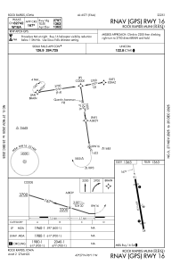


KRRQ - Rock Rapids Muni
Located in Rock Rapids, United States
ICAO - RRQ, IATA -
Data provided by AirmateGeneral information
Coordinates: N43°27'8" W96°10'47"
Elevation is 1363 feet MSL.
Magnetic variation is 05° East View others Airports in Iowa
Operational data
Special qualification required
Current time UTC:
Current local time:
Weather at : KLYV - Quentin Aanenson Fld ( 19 km )
METAR: KLYV 180135Z AUTO 32009KT 10SM BKN080 OVC090 11/04 A2999 RMK AO2
Communications frequencies: [VIEW]
Runways:
| RWY identifier | QFU | Length (ft) | Width (ft) | Surface | LDA (ft) |
| 16 | 172° | 3097 | 50 | ASPH | |
| 34 | 352° | 3097 | 50 | ASPH |
Airport contact information
Address: Rock Rapids United States