


KROA - Roanoke/Blacksburg Rgnl (Woodrum Fld)
Located in Roanoke, United States
ICAO - ROA, IATA - ROA
Data provided by AirmateGeneral information
Coordinates: N37°19'32" W79°58'32"
Elevation is 1175 feet MSL.
Magnetic variation is -08° East View others Airports in Virginia
Operational data
Special qualification required
Current time UTC:
Current local time:
Weather
METAR: KROA 281654Z 19007KT 150V220 10SM FEW050 28/13 A3022 RMK AO2 SLP224 T02780128 $
TAF: KROA 281120Z 2812/2912 34003KT P6SM SCT035 FM281400 22005KT P6SM FEW250 FM281800 17009KT P6SM SCT250 FM290300 24004KT P6SM SCT250
Communications frequencies: [VIEW]
Runways:
| RWY identifier | QFU | Length (ft) | Width (ft) | Surface | LDA (ft) |
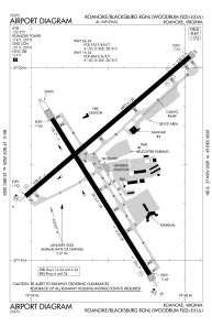
| 06 | 49° | 6800 | 150 | ASPH | 6800 |
| 24 | 229° | 6800 | 150 | ASPH | 6010 |
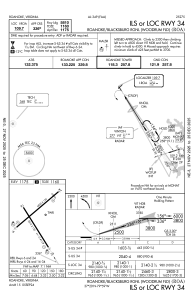
| 16 | 148° | 5810 | 150 | ASPH | 5810 |
| 34 | 328° | 5810 | 150 | ASPH | 5810 |
Airport contact information
Address: Roanoke United States
