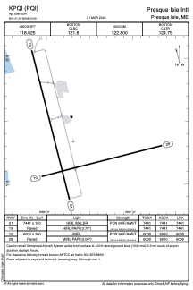


KPQI - Presque Isle Intl
Located in Presque Isle, United States
ICAO - PQI, IATA - PQI
Data provided by AirmateGeneral information
Coordinates: N46°41'20" W68°2'41"
Elevation is 534 feet MSL.
Magnetic variation is -17° East View others Airports in Maine
Operational data
Special qualification required
Current time UTC:
Current local time:
Weather
METAR: KPQI 291356Z AUTO 34019KT 10SM OVC022 07/02 A3003 RMK AO2 SLP199 T00720017
TAF: KPQI 291120Z 2912/3012 32011G22KT P6SM OVC022 FM291500 32012G22KT P6SM BKN035 FM291700 34015G26KT P6SM SCT050 FM300100 35009KT P6SM FEW220
Communications frequencies: [VIEW]
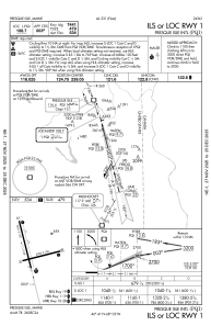
Runways:
| RWY identifier | QFU | Length (ft) | Width (ft) | Surface | LDA (ft) |
| 01 | 346° | 7441 | 150 | ASPH | 7441 |
| 19 | 166° | 7441 | 150 | ASPH | 7441 |
| 10 | 76° | 6000 | 100 | ASPH | 6000 |
| 28 | 256° | 6000 | 100 | ASPH | 6000 |
Airport contact information
Address: Presque Isle United States