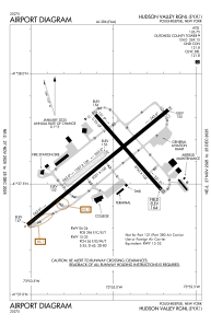


KPOU - Hudson Valley Rgnl
Located in Poughkeepsie, United States
ICAO - POU, IATA - POU
Data provided by AirmateGeneral information
Coordinates: N41°37'36" W73°53'3"
Elevation is 163 feet MSL.
Magnetic variation is -12° East View others Airports in New York
Operational data
Special qualification required
Current time UTC:
Current local time:
Weather
METAR: KPOU 052106Z VRB03KT 1 1/2SM -RA BR BKN013 OVC021 11/09 A3017 RMK AO2 P0001 T01060094
TAF: KPOU 052120Z 0521/0618 14003KT 4SM -RA BR OVC015 TEMPO 0521/0524 2SM RA BR OVC007 FM060200 VRB02KT 5SM BR VCSH SCT008 OVC015 FM060600 00000KT 4SM BR SCT008 OVC020 FM061400 17001KT P6SM BKN020
Communications frequencies: [VIEW]
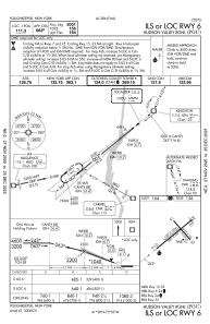
Runways:
| RWY identifier | QFU | Length (ft) | Width (ft) | Surface | LDA (ft) |
| 06 | 51° | 5001 | 100 | ASPH | 5001 |
| 24 | 231° | 5001 | 100 | ASPH | 4886 |
| 07 | 51° | 1357 | 100 | GRASS | |
| 25 | 231° | 1357 | 100 | GRASS | |
| 15 | 139° | 2743 | 100 | OTHER | 2743 |
| 33 | 319° | 2743 | 100 | OTHER | 2743 |
Airport contact information
Address: Poughkeepsie United States