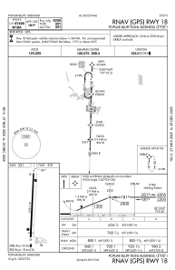
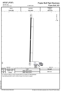


KPOF - Poplar Bluff Rgnl Business
Located in Poplar Bluff, United States
ICAO - POF, IATA -
Data provided by AirmateGeneral information
Coordinates: N36°46'26" W90°19'29"
Elevation is 330 feet MSL.
Magnetic variation is -00° East View others Airports in Missouri
Operational data
Special qualification required
Current time UTC:
Current local time:
Weather
METAR: KPOF 022353Z AUTO 15008KT 10SM -RA OVC110 21/17 A2983 RMK AO2 RAB39 SLP100 P0000 60000 T02110172 10283 20206 50004
Communications frequencies: [VIEW]
Runways:
| RWY identifier | QFU | Length (ft) | Width (ft) | Surface | LDA (ft) |
| 18 | 181° | 5008 | 100 | CONC | |
| 36 | 1° | 5008 | 100 | CONC |
Airport contact information
Address: Poplar Bluff United States