


KPKB - Mid-Ohio Valley Rgnl
Located in Parkersburg, United States
ICAO - PKB, IATA - PKB
Data provided by AirmateGeneral information
Coordinates: N39°20'42" W81°26'21"
Elevation is 858 feet MSL.
Magnetic variation is -08° East View others Airports in West Virginia
Operational data
Special qualification required
Current time UTC:
Current local time:
Weather
METAR: KPKB 271553Z 21013G23KT 10SM CLR 25/11 A3021 RMK AO2 PK WND 19026/1526 SLP223 T02500111
TAF: KPKB 271428Z 2714/2812 19008G14KT P6SM BKN060 FM272200 19007KT P6SM BKN090 FM280200 18006KT P6SM SCT200
Communications frequencies: [VIEW]
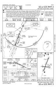
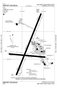
Runways:
| RWY identifier | QFU | Length (ft) | Width (ft) | Surface | LDA (ft) |
| 03 | 22° | 7240 | 150 | ASPH | 6780 |
| 21 | 202° | 7240 | 150 | ASPH | 6780 |
| 10 | 95° | 4002 | 150 | ASPH | 4002 |
| 28 | 275° | 4002 | 150 | ASPH | 4002 |
Airport contact information
Address: Parkersburg United States