


KPIR - Pierre Rgnl
Located in Pierre, United States
ICAO - PIR, IATA - PIR
Data provided by AirmateGeneral information
Coordinates: N44°22'58" W100°17'9"
Elevation is 1744 feet MSL.
Magnetic variation is 08° East View others Airports in South Dakota
Operational data
Special qualification required
Current time UTC:
Current local time:
Weather
METAR: KPIR 030253Z AUTO 33006KT 10SM CLR 07/02 A2985 RMK AO2 SLP114 T00720017 53016
TAF: KPIR 022333Z 0300/0324 31014KT P6SM BKN150 FM030100 29007KT P6SM SCT210 FM030300 25006KT P6SM FEW240 FM031500 30009KT P6SM BKN090 FM031800 29009KT P6SM VCSH OVC029 FM032200 25009KT P6SM OVC060
Communications frequencies: [VIEW]
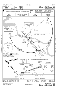
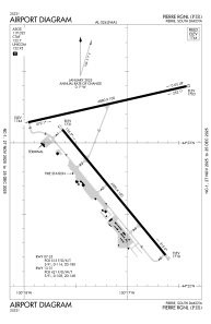
Runways:
| RWY identifier | QFU | Length (ft) | Width (ft) | Surface | LDA (ft) |
| 07 | 77° | 6880 | 150 | ASPH | 6830 |
| 25 | 257° | 6880 | 150 | ASPH | 6880 |
| 13 | 141° | 6900 | 100 | ASPH | 6900 |
| 31 | 321° | 6900 | 100 | ASPH | 6900 |
Airport contact information
Address: Pierre United States
