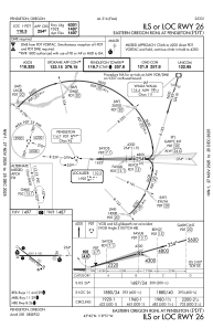
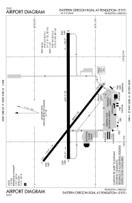


KPDT - Eastern Oregon Rgnl At Pendleton
Located in Pendleton, United States
ICAO - PDT, IATA - PDT
Data provided by AirmateGeneral information
Coordinates: N45°41'42" W118°50'36"
Elevation is 1494 feet MSL.
Magnetic variation is 16° East View others Airports in Oregon
Operational data
Special qualification required
Current time UTC:
Current local time:
Weather
METAR: KPDT 210953Z AUTO 17007KT 10SM CLR 11/03 A3011 RMK AO2 SLP189 T01060028
TAF: KPDT 210521Z 2106/2206 26015KT P6SM SKC FM210800 19005KT P6SM FEW120 SCT250 FM211500 25010KT P6SM SCT120 BKN250 FM211800 27015G25KT P6SM BKN120 BKN200 TEMPO 2200/2202 -RA FEW050 BKN080 OVC120 FM220200 25009KT 6SM -RA SCT015 BKN035 OVC050
Communications frequencies: [VIEW]
Runways:
| RWY identifier | QFU | Length (ft) | Width (ft) | Surface | LDA (ft) |
| 08 | 90° | 6301 | 150 | ASPH | 6301 |
| 26 | 270° | 6301 | 150 | ASPH | 6301 |
| 11 | 128° | 4809 | 100 | ASPH | 4809 |
| 29 | 308° | 4809 | 100 | ASPH | 4809 |
Airport contact information
Address: Pendleton United States
