


KPAO - Palo Alto
Located in Palo Alto, United States
ICAO - PAO, IATA - PAO
Data provided by AirmateGeneral information
Coordinates: N37°27'40" W122°6'54"
Elevation is 6 feet MSL.
Magnetic variation is 15° East View others Airports in California
Operational data
Special qualification required
Current time UTC:
Current local time:
Weather
METAR: KPAO 190347Z 34010KT 10SM SKC 13/09 A2993 RMK LAST
Communications frequencies: [VIEW]
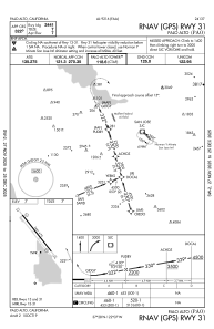
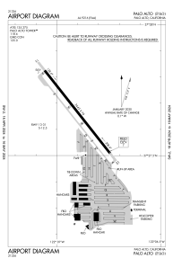
Runways:
| RWY identifier | QFU | Length (ft) | Width (ft) | Surface | LDA (ft) |
| 13 | 142° | 2443 | 70 | ASPH | |
| 31 | 322° | 2443 | 70 | ASPH |
Airport contact information
Address: Palo Alto United States

