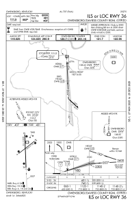
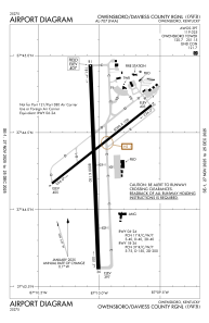


KOWB - Owensboro/Daviess County Rgnl
Located in Owensboro, United States
ICAO - OWB, IATA - OWB
Data provided by AirmateGeneral information
Coordinates: N37°44'20" W87°10'1"
Elevation is 407 feet MSL.
Magnetic variation is -04° East View others Airports in Kentucky
Operational data
Special qualification required
Current time UTC:
Current local time:
Weather
METAR: KOWB 300056Z 18004KT 10SM -RA FEW029 SCT037 OVC045 17/17 A2993 RMK AO2 LTG DSNT SE AND S SLP132 P0015 T01720167
TAF: KOWB 292320Z 3000/3024 VRB04KT P6SM VCSH BKN050 TEMPO 3001/3005 5SM -SHRA FM300500 VRB03KT P6SM BKN120 FM300800 VRB02KT 5SM BR BCFG SCT005 TEMPO 3008/3012 2SM BR BKN005 FM301500 34006KT P6SM SCT035
Communications frequencies: [VIEW]
Runways:
| RWY identifier | QFU | Length (ft) | Width (ft) | Surface | LDA (ft) |
| 06 | 52° | 5000 | 100 | OTHER | 5000 |
| 24 | 232° | 5000 | 100 | OTHER | 5000 |
| 18 | 178° | 8000 | 150 | CONC | 8000 |
| 36 | 358° | 8000 | 150 | CONC | 8000 |
Airport contact information
Address: Owensboro United States

