


KOTH - Southwest Oregon Rgnl
Located in North Bend, United States
ICAO - OTH, IATA - OTH
Data provided by AirmateGeneral information
Coordinates: N43°25'1" W124°14'49"
Elevation is 17 feet MSL.
Magnetic variation is 15° East View others Airports in Oregon
Operational data
Special qualification required
Current time UTC:
Current local time:
Weather
METAR: KOTH 280556Z AUTO 21010G16KT 10SM SCT009 OVC021 11/09 A3017 RMK AO2 RAB20E45 SLP217 P0001 60001 T01060094 10128 20106 51010
TAF: KOTH 280542Z 2806/2906 20006KT P6SM -SHRA OVC020 FM281700 23007KT P6SM VCSH BKN025 FM282000 25010KT P6SM VCSH SCT025 OVC040
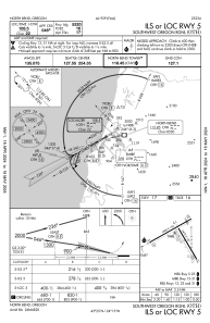
Communications frequencies: [VIEW]
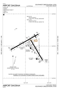
Runways:
| RWY identifier | QFU | Length (ft) | Width (ft) | Surface | LDA (ft) |
| 13 | 150° | 4470 | 150 | ASPH | 4470 |
| 31 | 330° | 4470 | 150 | ASPH | 4470 |
| 05 | 61° | 5980 | 150 | ASPH | 5320 |
| 23 | 241° | 5980 | 150 | ASPH | 5320 |
Airport contact information
Address: North Bend United States