


KORF - Norfolk Intl
Located in Norfolk, United States
ICAO - ORF, IATA - ORF
Data provided by AirmateGeneral information
Coordinates: N36°53'41" W76°12'4"
Elevation is 26 feet MSL.
Magnetic variation is -09° East View others Airports in Virginia
Operational data
Special qualification required
Current time UTC:
Current local time:
Weather
METAR: KORF 271051Z 10003KT 10SM SCT060 BKN095 12/08 A3044 RMK AO2 SLP307 T01220078
TAF: KORF 271120Z 2712/2812 10010KT P6SM BKN090 FM271400 13010KT P6SM BKN070 FM272200 15009KT P6SM BKN100 FM280500 18008KT P6SM SCT100
Communications frequencies: [VIEW]
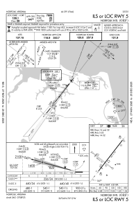
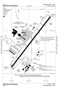
Runways:
| RWY identifier | QFU | Length (ft) | Width (ft) | Surface | LDA (ft) |
| 05 | 38° | 9001 | 150 | OTHER | 7809 |
| 23 | 218° | 9001 | 150 | OTHER | 8995 |
| 14 | 128° | 4876 | 150 | ASPH | 4300 |
| 32 | 308° | 4876 | 150 | ASPH | 3900 |
Airport contact information
Address: Norfolk United States