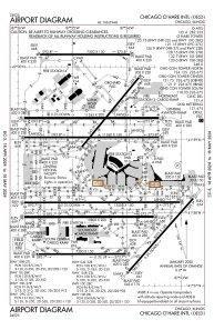


KORD - Chicago O'hare Intl
Located in Chicago, United States
ICAO - ORD, IATA - ORD
Data provided by AirmateGeneral information
Coordinates: N41°58'37" W87°54'29"
Elevation is 680 feet MSL.
Magnetic variation is -03° East View others Airports in Illinois
Operational data
Special qualification required
Current time UTC:
Current local time:
Weather
METAR: KORD 190951Z 28006KT 10SM FEW060 21/16 A2990 RMK AO2 SLP121 T02110156
TAF: KORD 190854Z 1909/2012 30005KT P6SM SKC FM191200 04010KT P6SM FEW350 FM200200 09007KT P6SM BKN300
Communications frequencies: [VIEW]
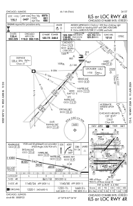
Runways:
| RWY identifier | QFU | Length (ft) | Width (ft) | Surface | LDA (ft) |
| 04L | 39° | 7500 | 150 | ASPH | |
| 22R | 219° | 7500 | 150 | ASPH | 7300 |
| 04R | 42° | 8075 | 150 | ASPH | 8075 |
| 22L | 222° | 8075 | 150 | ASPH | 8075 |
| 09C | 90° | 11245 | 200 | CONC | 11245 |
| 27C | 270° | 11245 | 200 | CONC | 11245 |
| 09L | 90° | 7500 | 150 | CONC | 7500 |
| 27R | 270° | 7500 | 150 | CONC | 7500 |
| 09R | 90° | 11260 | 150 | OTHER | 11260 |
| 27L | 270° | 11260 | 150 | OTHER | 11260 |
| 10C | 90° | 10800 | 200 | CONC | 10540 |
| 28C | 270° | 10800 | 200 | CONC | 10800 |
| 10L | 90° | 13000 | 150 | OTHER | 12246 |
| 28R | 270° | 13000 | 150 | OTHER | 13000 |
| 10R | 90° | 7500 | 150 | CONC | 7500 |
| 28L | 270° | 7500 | 150 | CONC | 7500 |
| H1 | 0° | 0 | 0 | UNK |
Airport contact information
Address: Chicago United States