


KORD - Chicago O'hare Intl
Located in Chicago, United States
ICAO - ORD, IATA - ORD
Data provided by AirmateGeneral information
Coordinates: N41°58'37" W87°54'29"
Elevation is 680 feet MSL.
Magnetic variation is -03° East View others Airports in Illinois
Operational data
Special qualification required
Current time UTC:
Current local time:
Weather
METAR: KORD 280451Z 18009KT 10SM FEW016 BKN028 OVC220 21/17 A2994 RMK AO2 SLP136 T02060172
TAF: KORD 280259Z 2803/2906 20012G20KT P6SM BKN025 FM280600 20012G20KT 5SM -SHRA VCTS BKN025CB TEMPO 2806/2810 2SM TSRA BR BKN015CB FM281200 20011G18KT P6SM BKN018 FM281700 06010KT P6SM VCSH BKN012 FM290000 16014G22KT P6SM BKN035 PROB30 2903/2906 3SM TSRA BKN025CB
Communications frequencies: [VIEW]
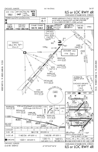
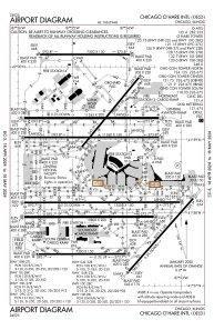
Runways:
| RWY identifier | QFU | Length (ft) | Width (ft) | Surface | LDA (ft) |
| 04R | 42° | 8075 | 150 | ASPH | 8075 |
| 22L | 222° | 8075 | 150 | ASPH | 8075 |
| 04L | 39° | 7500 | 150 | ASPH | 7500 |
| 22R | 219° | 7500 | 150 | ASPH | 7300 |
| 09R | 90° | 11260 | 150 | OTHER | 11260 |
| 27L | 270° | 11260 | 150 | OTHER | 11260 |
| 09L | 90° | 7500 | 150 | CONC | 7500 |
| 27R | 270° | 7500 | 150 | CONC | 7500 |
| 10L | 90° | 13000 | 150 | OTHER | 12246 |
| 28R | 270° | 13000 | 150 | OTHER | 13000 |
| 10C | 90° | 10800 | 200 | CONC | 10540 |
| 28C | 270° | 10800 | 200 | CONC | 10801 |
| 10R | 90° | 7500 | 150 | CONC | 7500 |
| 28L | 270° | 7500 | 150 | CONC | 7500 |
| 09C | 90° | 11245 | 200 | CONC | 11245 |
| 27C | 270° | 11245 | 200 | CONC | 11245 |
Airport contact information
Address: Chicago United States