


KOMA - Eppley Airfield
Located in Omaha, United States
ICAO - OMA, IATA - OMA
Data provided by AirmateGeneral information
Coordinates: N41°18'11" W95°53'39"
Elevation is 984 feet MSL.
Magnetic variation is 02° East View others Airports in Nebraska
Operational data
Special qualification required
Current time UTC:
Current local time:
Weather
METAR: KOMA 271252Z 25005KT 10SM FEW100 SCT200 13/10 A2974 RMK AO2 SLPNO T01280100 $
TAF: KOMA 271120Z 2712/2812 31005KT P6SM SCT220 FM271900 02006KT P6SM BKN040 FM272300 02009KT 4SM -TSRA BKN030CB FM280100 03009KT 5SM -SHRA OVC040 FM280400 08010KT 6SM -SHRA OVC013
Communications frequencies: [VIEW]
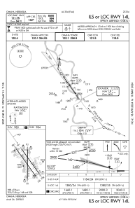
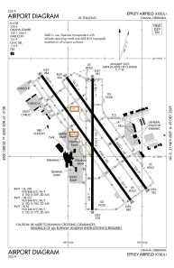
Runways:
| RWY identifier | QFU | Length (ft) | Width (ft) | Surface | LDA (ft) |
| 14R | 144° | 9502 | 150 | CONC | 9502 |
| 32L | 324° | 9502 | 150 | CONC | 9502 |
| 14L | 144° | 8500 | 150 | CONC | 8500 |
| 32R | 324° | 8500 | 150 | CONC | 8500 |
| 18 | 180° | 8154 | 150 | CONC | 8013 |
| 36 | 0° | 8154 | 150 | CONC | 8153 |
Airport contact information
Address: Omaha United States
