


KOKB - Bob Maxwell Meml Airfield
Located in Oceanside, United States
ICAO - OKB, IATA -
Data provided by AirmateGeneral information
Coordinates: N33°13'5" W117°21'5"
Elevation is 28 feet MSL.
Magnetic variation is 13° East View others Airports in California
Operational data
Special qualification required
Current time UTC:
Current local time:
Weather
METAR: KOKB 251652Z AUTO 29007KT 7SM OVC046 17/10 A3011 RMK AO2 SLP194 T01670100
Communications frequencies: [VIEW]
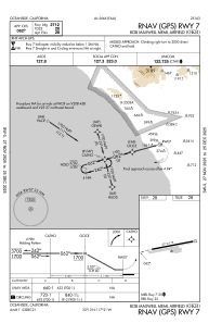
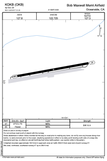
Runways:
| RWY identifier | QFU | Length (ft) | Width (ft) | Surface | LDA (ft) |
| 07 | 80° | 2712 | 75 | ASPH | |
| 25 | 260° | 2712 | 75 | ASPH |
Airport contact information
Address: Oceanside United States