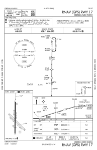


KOIN - Oberlin Muni
Located in Oberlin, United States
ICAO - OIN, IATA -
Data provided by AirmateGeneral information
Coordinates: N39°50'4" W100°32'23"
Elevation is 2706 feet MSL.
Magnetic variation is 06° East View others Airports in Kansas
Operational data
Special qualification required
Current time UTC:
Current local time:
Weather
METAR: KOIN 281835Z AUTO 33012G17KT 10SM BKN026 OVC035 12/07 A2988 RMK AO1 T01170069
Communications frequencies: [VIEW]
Runways:
| RWY identifier | QFU | Length (ft) | Width (ft) | Surface | LDA (ft) |
| 17 | 180° | 4301 | 60 | ASPH | 4301 |
| 35 | 0° | 4301 | 60 | ASPH | 3501 |
| 12 | 135° | 2832 | 130 | GRASS | |
| 30 | 315° | 2832 | 130 | GRASS |
Airport contact information
Address: Oberlin United States