


KOGM - Ontonagon County/Schuster Fld
Located in Ontonagon, United States
ICAO - OGM, IATA -
Data provided by AirmateGeneral information
Coordinates: N46°50'44" W89°22'2"
Elevation is 665 feet MSL.
Magnetic variation is -03° East View others Airports in Michigan
Operational data
Special qualification required
Current time UTC:
Current local time:
Weather at : KIWD - Gogebic/Iron County ( 68 km )
METAR: KIWD 210056Z AUTO 34005KT 7SM OVC005 12/11 A2988 RMK AO2 SLP122 T01170111
TAF: KIWD 210028Z 2100/2124 VRB04KT P6SM OVC005 FM210600 00000KT 1SM BR BKN014 FM211300 VRB04KT P6SM BKN008 FM211700 10008KT P6SM VCSH OVC014 FM212200 12013G21KT P6SM -SHRA BKN021
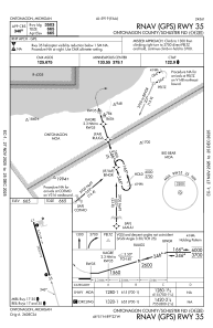
Communications frequencies: [VIEW]
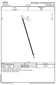
Runways:
| RWY identifier | QFU | Length (ft) | Width (ft) | Surface | LDA (ft) |
| 17 | 163° | 3503 | 75 | ASPH | |
| 35 | 343° | 3503 | 75 | ASPH |
Airport contact information
Address: Ontonagon United States