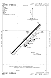


KOAJ - Albert J Ellis
Located in Jacksonville, United States
ICAO - OAJ, IATA - OAJ
Data provided by AirmateGeneral information
Coordinates: N34°49'45" W77°36'44"
Elevation is 92 feet MSL.
Magnetic variation is -08° East View others Airports in North Carolina
Operational data
Special qualification required
Current time UTC:
Current local time:
Weather
METAR: KOAJ 072256Z 25005KT 10SM CLR 28/21 A2978 RMK AO2 LTG DSNT SE TSB00E15 SLP087 T02830206 $
TAF: KOAJ 072335Z 0800/0824 26010KT P6SM FEW050 SCT250 FM081700 23010G18KT P6SM SCT040 AMD LTD TO CLD VIS AND WIND
Communications frequencies: [VIEW]
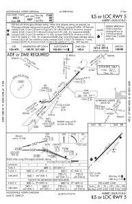
Runways:
| RWY identifier | QFU | Length (ft) | Width (ft) | Surface | LDA (ft) |
| 05 | 44° | 7100 | 150 | ASPH | |
| 23 | 224° | 7100 | 150 | ASPH |
Airport contact information
Address: Jacksonville United States